February 18, 2023: The alarm on my watch rings at 03:00 am - I'm still waiting for the weather report via satellite, the wind is rattling my tent outside. It storms. Then, at 3:34 a.m., the report comes that the storm is supposed to die down, so from 9 a.m. on there's only 20km/h wind. As I left the tent, I was swallowed up by the stormy darkness.
The fine snow that hits me feels like a sewing machine running over my face. I don't know exactly how cold it is, I specifically asked not to get that information from the weather report. It helps to cope with these extreme conditions and if I'm honest the temperature itself is irrelevant, what counts is the wind, if it's low enough it might work out with the summit today.

Most remote wilderness
10 days ago, a small plane dropped me off on the glacier more than 25km from here. Since then, I haven't seen a soul, not even a bird. The arctic winter is relentless, the rangers of the national park had also warned me about that. There is no rescue, because the planes are not on site in winter and even if the plane, I landed with would come to pick me up, there can be such bad weather for up to two weeks that it cannot land.

Just in case, I buried food and fuel deep in the snow at the landing site, because by now the giant ravens you usually see here have learned that a marker pole can mean food and started digging up to a meter deep.
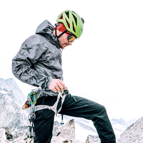
From this point I then pulled my 64 kilo sled through the powder snow, using skis that I have fitted with an old Silvretta binding so that I can clamp my 8000 meter mountain boots onto them, a normal ski boot would be unthinkable at the low temperatures.

The skis distribute my weight better and I minimize the risk of falling into a crevasse, one of the biggest risks for me as a solo mountaineer. Should I still fall into a crevasse, I have assembled a set of two ice screws. With this set I can then pull myself up on one screw and then place the next one above it, to then pull on it and so on. However, this is just a backup for an absolute emergency, I'm really on my own here, alone, in the wilderness - Just the way I like it.
This route has not been climbed in winter yet
My goal today is the Messner Couoloir. It's a beautiful line that can be seen from the penultimate camp at 14,000 feet (about 4,267 meters) and has never been climbed through in winter. That's part of the fascination, the unknown that lurks there, not knowing if it's even possible. There are usually good reasons why something hasn't been done yet.
Now I'm in the lower part of the couloir - it's icy from the storm, the snow has been completely blown away, leaving only hard blue-white. Fortunately, I don't have to do any tracking work, but instead it's energy-sapping to slam my ultra-light carbon picks (which feel warmer than aluminum picks) into the hard ice. In between there are snow bridges that require careful handling and a zigzag course.
Then I finally reach the place where the rock has the shape of an hourglass filled with snow. From here I continue on firn and broken hard snow, made more difficult by the 10 m2 of snow slabs that lie on an old layer of snow and can break off.
In the ranger's office I was warned that an experienced solo alpinist was killed when he took advantage of the good climbing properties of the compressed snow of these snow slabs and one came loose when he was on it, dragging him down with it. So, I bypass the snow slabs and wind my way up the mountain.

When I reach the end of the Messner Couloir it is already dark again, the days of the polar winter are only very short and often there is only a long twilight phase. In the dark I feel my way forward and navigate primarily with the GPS of my watch - previously I downloaded the GPS files of the normal route and now I am on the route. A short time later I see some marker flags, or rather the scraps that the winter storms have left of them.
Minus 70 degrees and new moon
The track of the normal season was chiseled into the ice by wind and weather. I follow it on a ridge further and further up until I suddenly arrive at a peak. But something is wrong, my GPS shows that I have gone off track and the altitude is also too low.
While the pilot team from Talkeetna, the village from where I flew to the mountain, already knows that I made a little detour to Archdeacon Tower, I am still navigating. To get visual references, I sit down on the summit and turn off the headlamp. As it was a new moon and there were still clouds in the sky, I stared into the pitch-black sky, after about 40 minutes, I could make out the outlines of the surroundings. There is still something larger, higher, which lurks there.
I descend until I hit another trail from the summer. I'm on what's called Football Field, a huge wide and flat area where it's easy to get lost. After that it starts to climb again, a good sign I think, until I get the last few meters up to the ridge, where the wind is roaring.
I drag myself as fast as I can along the ridge to the summit, the gusts regularly force me to my knees, where I claw both ice axes into the snow. Every little tower on the ridge seems like the summit, but my GPS sends me further and further into the darkness until my watch finally vibrates and announces the arrival. For safety's sake I check again briefly whether I'm really at the highest point, would be annoying if I had to come here again, just because of a few meters.
Then everything goes lightning fast - I get out my satellite tracker and send my coordinates by message home. It's so cold that my eyes freeze over. The hand I used to operate it has gone numb in this 4 minute break. I quickly sprint down the mountain and hope I didn't get frostbite on my fingers, they can jeopardize the descent. My feet are numb, my body like wood.
I climb down even further through the darkness following my GPS on a route I've never been on before. The blue ice at Messner Couloir is too risky in this storm. There are 55 km/h constant winds and minus 45 degrees, with windchill effect that equals minus 70 degrees. When the GPS finally fails due to the low temperatures, I improvise until I finally arrive back at my tent after 35.5 hours.

The summit is only half way
And here the expedition is not over yet, I still have to cover 25 kilometers, dodge a storm with all the equipment, dig snow caves and finally wait almost a week for the plane to pick me up.
In order for the plane to land, I have to compress a 2,700 m2 runway with my skis, otherwise the plane's ski runners will sink into the deep snow. So, a lot of running back and forth until a 150 m long runway and 50 m long landing runway with a curve are completed.
Good thing I didn't know that before, because that was pretty hard ;)